Across America on a Janus Motorcycle – Part 3
October 22, 2019
Share this post
OVER THE SIERRAS AND ACROSS THE GREAT DESERTS
On Monday May 26th, I woke up at 5:00am with all but my riding gear packed and ready to go in the panniers. My riding gear consisted of a two-piece armored textile suit, under which I wore my LDComfort base layers. A dual-sport helmet, riding boots, armored gloves, and a Camelback hydration system, with a hi-viz yellow vest completed what I actually carried on me while I rode.
I left the motel around 6:00am, fueled up, and set my trip meter, and headed east towards Sacramento. The odometer on the bike read 1,402 miles. I noted this and decided, in the interest of time, to head up over the Sierra Nevadas on interstate 80 as all other routes would take too long to allow me to realistically reach our rendezvous point in Wells, Nevada with any time to sleep. The first few miles were familiar to me as I had already covered them on my way into San Francisco, but this time rather than heading across the Bay Bridge, I continued on through Oakland, Berkeley, Richmond, and on through Vellejo. The early morning sun felt wonderful as the fog lifted off the bay and I began to ride through rolling brown hills with the patchwork of green agricultural fields on my way up to Sacramento. I quickly found that the bike with the modified gearing would just top 60 miles per hour, but that the rpms were smooth and even. Aware that a consistent ride pace would be key to successful long distance “ride craft”, I was happy to maintain these lower rpms, which in turn would mean less vibration and wear on the bike.
Just short of Sacramento, I felt the bike give a sputter and shut off. As I pulled to the side of the highway, I checked my trip meter which showed 90 miles—I had established my fuel range! During our emissions certification process, the EPA assigned the engine and drivetrain on all three Janus models a fuel economy of 77 miles per gallon. Just like all vehicles, this number represents the fuel economy at the most efficient speeds, which in our case range from 45 to 55 miles per hour. Anecdotal evidence from our owners has shown the average operational fuel economy to be around 60 miles per gallon. In my case, with sustained interstate speeds, I averaged around 50 miles per gallon for most of the trip, although that figure did improve as I descended the Rockies toward the Midwest. Comfortable with the knowledge of my spare fuel, I unlocked the Rotopax fuel can, and emptied its one gallon into the main tank which got me down the road to an easily accessible gas station. While I was filling up, Tim Masterson gave me a call to check in and see how I was doing. My Spotwalla tracker was working and he and Cliff, the ride master, were able to see exactly where I was.
Back in the saddle, I headed up out of the Sacramento Valley and into the foothills of the Sierra Nevadas. As I gradually gained elevation, the brown rolling hills grew and the their slopes began to show a covering of trees. The hills gradually became steeper and steeper with the Halcyon sometimes slowing to 50 or even 45 miles per hour on the steepest grades. Luckily, the trucks were having it harder than I was so I had plenty of slow moving traffic to keep me company. When a space would open up I would leap frog past the trucks as we began to wind up the rocky ravines leading to the famous Donner Pass. Easily visible from the road were numerous clear streams of melting snow rushing down over rocks and fallen trees. When George Wyman made his first crossing of the Sierra Nevadas in 1902 the easiest way to cross the mountains was to follow the transcontinental railroad which also summits at the Donner Pass. Because of the deep snow and constant risk of avalanches, the then Central Pacific Railroad (now Union Pacific Railroad) used miles of long wooden sheds that covered the tracks leading up and over the pass. Wyman completed the 54-mile climb to the Donner Summit in a day—quite a feat when much of that was walked along the railroad ties!
“Then I struck the snow, and as promptly I hurried for the shelter of the snow sheds, without which there would be no travel across continent by the northern route. The snow lies 10, 15, and 20-feet deep on the mountain sides, and ever and anon the deep boom or muffled thud of tremendous slides of “the beautiful” as it pitches into the dark deep canyons or falls with terrific force upon the sheds conveys the grimmest suggestions. The sheds wind around the mountain sides, their roofs built aslant that the avalanches of snow and rock hurled from above may glide harmlessly into the chasm below. Stations, section houses, and all else pertaining to the railways are, of course, built in the dripping and gloomy, but friendly, shelter of these sheds, where daylight penetrates only at the short breaks where the railway tracks span a deep gulch or ravine.
To ride a motor bicycle through the sheds is impossible. I walked, of course, dragging my machine over the ties for 18 miles by cyclometer measurement. I was 7 hours in the sheds. It was 15 feet under the snow. That night I slept at Summit, 7,015 feet above the sea, having ridden – or walked – 54 miles during the day.”
Today, the sheds are still in use, but the original wood has been replaced with concrete. I was able to spot numerous sections of these concrete sheds from the interstate as we wound up towards the summit. At the Donner Summit I pulled over to snap a few pictures. At this point I realized that my USB charging port that we had installed on the bike was not working properly. After a few minutes riding, the phone would stop charging and flash a warning message that read “device not recognized”. This was troublesome, as I needed the ability to charge the phone on the bike, especially running Google maps which tends to drain an iPhone battery very quickly. I tried charging with the engine off, which did work, however, this wouldn’t be the solution to crossing the country!
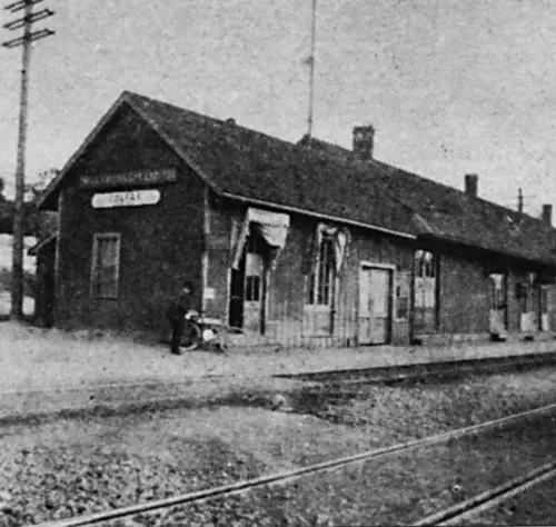
Wyman’s photograph of at the Colfax Depot, near the Donner Summit with his bike leaned against the station.
After reading Wyman’s journal entries of the difficulties of crossing the Sierra Nevadas, I was struck with how much has changed—from internal combustion engines, motorcycles, roads, and the communication that allowed me to instantly send pictures of the bike at the summit to the rest of the Janus crew back in Goshen, Indiana, some 2,000 miles to the east.
After what I later would learn was long break (much of which spent charging the phone), I remounted and headed down the much steeper west side of the range towards Donner Lake, Truckee, and the Nevada border. The cool crisp air, gorgeous scenery, and excitement of my first day on the road had me in high spirits. It wasn’t long before I crossed into Nevada and decided to stop for fuel and lunch in Reno. I stopped at a run down gas station with slot machines and ate a sandwich. Back in the saddle, the scenery quickly changed from the green pine-clad mountains I had been surrounded with, to pale browns and reds of the desert that opened up without warning. The previous evening, Tim recommended that I take a slight detour off of I80 at Fernley to the town of Fallon, Nevada. This would afford me some perfect desert riding and a closer route to that of Wyman. I decided to follow Tim’s advice, knowing that this would probably add a considerable about of time to the day’s ride, however, I really wanted to experience riding through the desert, especially on a smaller road.

At Donner Pass, the summit of my crossing of the Sierra Nevadas
When I reached Fallon, I stopped at a Walmart and picked up a battery charging pack for the phone. This would allow me to charge the phone up to 4 times which I figured would be enough to get me through a day of riding. Meanwhile with three longer rests and picture breaks, plus numerous fueling stops, it was much later in the day than I realized. I hopped back on the bike to rejoin I80 32 miles to the north. This stretch of road proved to be exactly what I had been looking for. Flat desert, with traces of white that I took to be salt stretching on for miles with distant mountains and not a car in sight. Pulling over at a particularly picturesque spot, I found fellow Wyman rider, Joe Green on his BMW R1200 GS adventure bike.
When I reached Fallon, I stopped at a Walmart and picked up a battery charging pack for the phone. This would allow me to charge the phone up to 4 times which I figured would be enough to get me through a day of riding. Meanwhile with three longer rests and picture breaks, plus numerous fueling stops, it was much later in the day than I realized. I hopped back on the bike to rejoin I80 32 miles to the north. This stretch of road proved to be exactly what I had been looking for. Flat desert, with traces of white that I took to be salt stretching on for miles with distant mountains and not a car in sight. Pulling over at a particularly picturesque spot, I found fellow Wyman rider, Joe Green on his BMW R1200 GS adventure bike.
The Fallon, NV detour.
Halcyon #068 in new surroundings north of Fallon, Nevada.
Apparently, Joe had missed Tim and Cliff’s warning and had attempted one of the harder-to-access waypoints. The road had gone from asphalt to gravel, gravel to dirt, and dirt to sand, and Joe had dropped his bike not once, but 3 times before he had decided to turn around. The last time he went down, the big BMW had caught his leg under one of his aluminum panniers. Joe said that when he looked at his foot it was pointed the wrong way. Overall, not a great thing to discover by yourself in the middle of the desert. After considerable effort, Joe was able to extract his foot to fortunately discover that it had twisted around inside the boot. Apart from some bruises and sore muscles, he would be able to continue the ride. I called into to Tim and let him know that all was well and got back in the saddle. Once on I80 again, I settled back into the long highway miles. Here the highway wound its way through desert valleys with the railroad track never too far distant.
Joe Green with his trusty BMW at Lotta’s Fountain ready to start the 3500-mile trip.Throughout the day, I was passed several times by John and Nadine Huval, Louisiana-based long distance riders riding two-up on their big Honda Goldwing. A quick wave and they would be gone ahead of me, taking numerous detours and stops in their attempt to collect Wyman waypoints.
Toward the end of the day, I was afforded a spectacular view of distant rain with the foot of a rainbow. This was one of only two times on the trip that I would actually feel any rain, although I needn’t have donned my rain gear, as the storm passed as quickly as it had appeared with barely a sprinkle along my route. As the sun went down, I spotted the bright riding lights of a fellow rider behind me. Joe Green decided to keep me company, slowing his pace for the last few hours of the day’s ride. It was late when we finally arrived at the Iron Skillet in Wells, Nevada. A quick bite to eat, cover on the bike, and I was showered, packed for the morning, and in bed with my first 600-mile day under my belt.

The Huvals getting off the interstate to pick up a Wyman waypoint.

Rainbow over a Nevada valley.